Gambling on the weather and being rewarded with dramatic views and a deserted path.
In earlier posts I relate how, as I approached 70, I became convinced that my fellwalking days were over and describe a walk around the Langdale Pikes that marked the start of my recovery from this torpor and got me thinking that maybe I’m not quite finished with the fells.
In this post, the second in a series of “Over The Hill Hikes” (OTHHs), I recall a wonderful walk that put me firmly back on the right track.
| WALK | A walk around the peaks (including 5 “Wainwrights”) surrounding Coledale, a valley situated in the north western fells, near Keswick. |
| START/ FINISH | Braithwaite, at a small parking area on the B5292 road to the Whinlater pass ( NY 227238). Failing that, there is plenty of roadside parking in the village. |
| DISTANCE | 9.4 miles. |
| ASCENT | 3,990 ft |
| TERRAIN | One very long, steep climb, then several substantial ups and downs. A couple of sections on the descent from Crag Hill need a little care, particularly when wet. |
| PUB | The Coledale Inn. (NY 230235) |
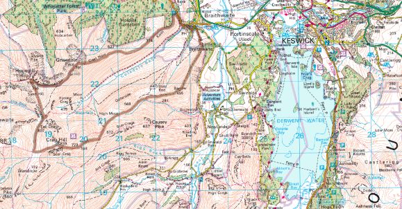
I call this blog “A” Coledale Round because the route I followed differs from the one described by Wainwright by omitting Outerside, a low-level fell which sits in the middle of Coledale and walking around its base instead.
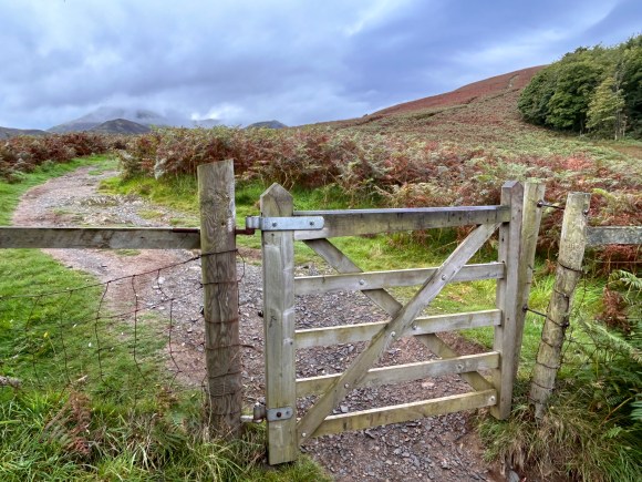
Braithwaite to Grisedale Pike
From the parking area on the B 5292 take the path that goes uphill from the right-hand side as you turn in from the road. The level footpath to the left leads to the mine road that takes you along Coledale, to the now disused Barytes mine below Force Crag and eventually over Coledale Hause, of which more later.
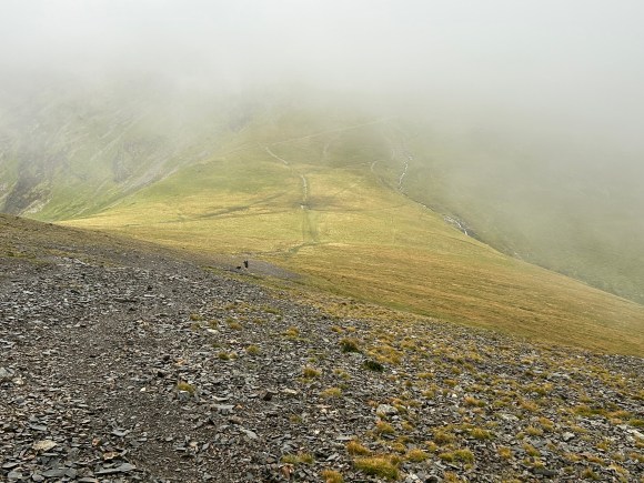
After an initial steep section, the path eases before the first major climb up to Sleet How. A bit of respite is provided by another relatively flat stretch before the path rises steeply again and continues along the ridge to the top. At this point the summit normally comes into view, but there’s no chance of that today as I’m soon enveloped by low cloud and persistent rain. The final 500ft or so involves clambering (slowly and inelegantly in my case) over exposed, slippery rock.
Grisedale Pike is an imposing landmark when viewed from Keswick. Wainwright considered it;
“One of those fells that compels attention by reason of shapeliness and height”.
There is generally a great view from the top but, as I neared the summit, I saw nothing but a cold, damp greyness.
The top of Grisedale is exposed at the best of times, but particularly so on this visit, so I don’t hang around in the wind, driving rain and non-existent view; staying just long enough to reflect on how nice it is to get the toughest bit of a walk over with first.
Grisedale Pike to Coledale Hause
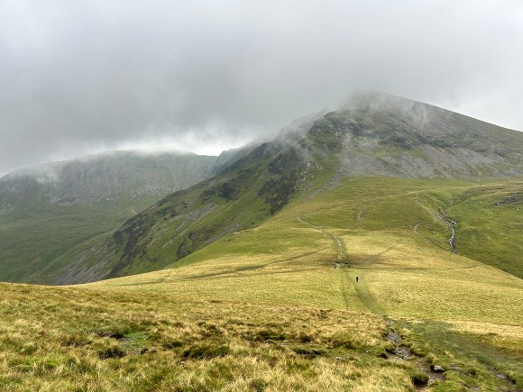
After an initially steep descent from Grisedale Pike, the path continues its exhilarating way along the top of Hobcarton Crag before climbing to Hopegill Head.
A fine drizzle was now falling and the tops were hidden in cloud as I walked along the top of the crag. I determined that if the weather didn’t improve, I’d admit defeat at Coledale Hause and retreat down the valley rather than complete the full horseshoe.
As the cloud began to rise and fall, I got tantalising glimpses of the magnificently dark and brooding Hobcarton crag along with the summit of its subsidiary peak, Ladyside Pike. This is a wonderful place to be in any weather.
Stumbling along the broken slate path, I was surprised by a group of mountain bikers who suddenly appeared out of the mist behind me to break my splendid isolation. They confirmed that the rocky ascent to Grisedale Pike had been hard work, but that the downhills amply compensated. The bikes seemed to have good suspension, but I fancy the riders would also need suspension in their buttocks if they were to avoid a severe case of bikers-bum. They were still in good spirits though when I caught up with them again, enjoying a break on Hopegill Head and debating where to go next.
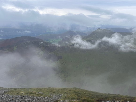
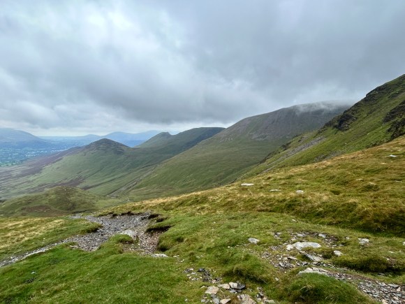
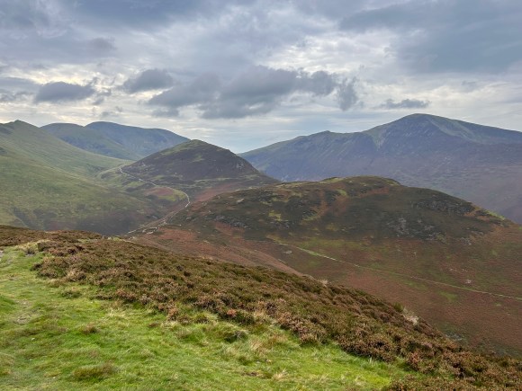
Cloud still shrouded the summit, so without stopping at the cairn I dropped down over Sand Hill to Coledale Hause, where it again cleared to reveal a superb view down both sides of the pass. On the Coledale side there was an extensive view all the way down the valley, over the Vale of Keswick towards the Skiddaw group. On the other side, the path wended its delightful way through Gasgale Gill to Langthwaite and Crummock Water: a delightful walk I’d heartily recommend.
The weather improved as I approached my ‘decision point’ at Coledale Hause and I decided I had no excuse to retreat down the valley, so pressed on, feeling more optimistic now.
Coledale Hause to the col below Sail.
The Hause is a great spot for lunch and I recalled stopping here for a sarnie a few years ago while doing the “Inn Way to The Lakes” with my brother-in-law. That day we were in shorts and tee shirts and spent some time enjoying the sun, views and lunch. Today, the biting wind meant that it was too cold to linger over my cheese and jam butty before the relatively easy ascent to the col between Crag Hill and Grasmoor. When I was younger, I sometimes turned right at the col and added the imposing lump of Grasmoor to the round – but not today thank you!
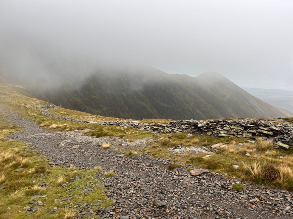
No, today I turn left at the col and follow the wide, well-beaten path up to Crag Hill, where the cloud now frustratingly sat just on the summit, obscuring any views. However, the outlook soon improved dramatically as I quickly walked out of the cloud on the descent along a fine ridge east of Crag Hill (The Scar). Here there are a couple of tricky rock sections to scramble down. I didn’t find these as easy as I once did, as my balance and nerve on such ground is not what it once was – less mountain goat and more acting the goat – evidenced by my comical wobbling hesitancy as I gingerly descend. Wainwright warned of these sections thus;
“Timid walkers will be aware of their disability at two places where rock must be descended, but may safely venture.”
“Disability” is an odd way to describe timidity on steep rock, especially for one normally so articulate, but “different times”, as they say at the BBC.
Anyhow, disabled or not, I “safely ventured”, despite the wet rock making it a slippery experience – I was grateful that this Coledale clown show had not been witnessed by giggling fellow hikers. As I dropped to the col between Crag Hill and Sail the cloud parted for the final time and I was rewarded with a more extensive view to the south east over Newlands to Robinson, whose summit remained elusively hidden.
The easy climb to Sail is followed by a long, well-made zig-zag path downhill. As the cloud continued to clear I got great views towards Keswick, Derwentwater, Catbells and the Maiden Moor ridge.
The col below Sail to Braithwaite
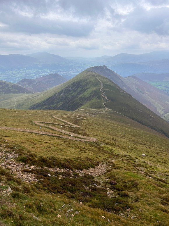
At the col the path continues over Scar Crags and Causey Pike, another option providing a longer round and one that I’ve taken in the past. Today I turn left along a descending path which is initially steep and rocky in places but soon levels off nicely as it joins an old mine road providing a relatively easy path along the flanks of Outerside to Barrow Door, where you can take a short cut back to the village.
However, having come this far it would be a crime not to proceed to the final highlight of a day filled with highlights by climbing Barrow and descending to Braithwaite along a superb ridge giving excellent views towards Bassenthwaite Lake and beyond. By the time I reached Barrow the cloud had lifted completely off the tops and looking behind me I could see most of the round.
The ridge path down to Braithwaite is a great end to a memorable walk and fully deserves Wainwright’s observation that “every step is a joy”.
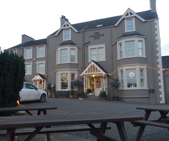
From Braithwaite Lodge, at the foot of the ridge, the route back to the parking area will take you past the Coledale Inn. This is an atmospheric country inn built in 1824 as a woollen mill, later becoming a pencil factory before transitioning to a licensed premises.
The inn always has a few real ales on tap and dishes up good hearty walkers fare. On a fine day the garden is a wonderful place to celebrate a great day on the hills: a few years ago, I saw legendary mountaineer and Cumbrian resident Chris Bonnington enjoying a pint there after a walk with a few mates. I admired Chris’ patience as he posed for endless selfies with overly-excited admirers.
The last word goes to Wainwright, who described one of his favourite walks thus;
“A walk that ranks among the best in sustained interest and in the excellence of the views from each of the six summits attained” and stated that “the round will be remembered with affection by those who walk around the mountain skyline of its perimeter and by so doing enjoy one of their most rewarding days on the tops”.
DISCLAIMER
I can take no responsibility for any loss or injury caused by following the above walk. The description is an accurate outline of the route and should enable you to follow the walk on an OS map, but the walk should not be attempted without a map, compass and the ability to use them!
Discover more from Over the hill - on Dartmoor & in Lakeland. I
Subscribe to get the latest posts sent to your email.
